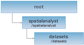
<spatialAnalyst_uri>/datasets.[<format>]
Returns a list of datasets.
Supported methods:
Supported output formats: rjson, json, html, xml.

Below is an example of performing an HTTP request on a URI with rjson as the output format. supermapiserver in the URI is the name of the server.
http://supermapiserver:8090/iserver/services/spatialanalyst-sample/restjsr/spatialanalyst/datasets.rjson
Gets information about all the datasets under the datasource.
After a GET request is performed on the datasets resource: http://supermapiserver:8090/iserver/services/spatialanalyst-sample/restjsr/spatialanalyst/datasets.rjson, a set of descriptions is returned, with each {} containing the RJSON string description of an individual dataset, as shown below:
[
{
"name": "SamplesP@Interpolation",
"path": "http://supermapiserver:8090/iserver/services/spatialanalyst-sample/restjsr/spatialanalyst/datasets/SamplesP%40Interpolation",
"resourceConfigID": null,
"resourceType": null,
"supportedMediaTypes": null
},
{
"name": "Railway_L@Jingjin",
"path": "http://supermapiserver:8090/iserver/services/spatialanalyst-sample/restjsr/spatialanalyst/datasets/Railway_L%40Jingjin",
"resourceConfigID": null,
"resourceType": null,
"supportedMediaTypes": null
},
{
"name": "Province_L@Jingjin",
"path": "http://supermapiserver:8090/iserver/services/spatialanalyst-sample/restjsr/spatialanalyst/datasets/Province_L%40Jingjin",
"resourceConfigID": null,
"resourceType": null,
"supportedMediaTypes": null
},
{
"name": "River_L@Jingjin",
"path": "http://supermapiserver:8090/iserver/services/spatialanalyst-sample/restjsr/spatialanalyst/datasets/River_L%40Jingjin",
"resourceConfigID": null,
"resourceType": null,
"supportedMediaTypes": null
},
{
"name": "County_T@Jingjin",
"path": "http://supermapiserver:8090/iserver/services/spatialanalyst-sample/restjsr/spatialanalyst/datasets/County_T%40Jingjin",
"resourceConfigID": null,
"resourceType": null,
"supportedMediaTypes": null
},
{
"name": "Neighbor_R@Jingjin",
"path": "http://supermapiserver:8090/iserver/services/spatialanalyst-sample/restjsr/spatialanalyst/datasets/Neighbor_R%40Jingjin",
"resourceConfigID": null,
"resourceType": null,
"supportedMediaTypes": null
},
{
"name": "BaseMap_P@Jingjin",
"path": "http://supermapiserver:8090/iserver/services/spatialanalyst-sample/restjsr/spatialanalyst/datasets/BaseMap_P%40Jingjin",
"resourceConfigID": null,
"resourceType": null,
"supportedMediaTypes": null
},
{
"name": "BaseMap_R@Jingjin",
"path": "http://supermapiserver:8090/iserver/services/spatialanalyst-sample/restjsr/spatialanalyst/datasets/BaseMap_R%40Jingjin",
"resourceConfigID": null,
"resourceType": null,
"supportedMediaTypes": null
},
{
"name": "BaseMap_L@Jingjin",
"path": "http://supermapiserver:8090/iserver/services/spatialanalyst-sample/restjsr/spatialanalyst/datasets/BaseMap_L%40Jingjin",
"resourceConfigID": null,
"resourceType": null,
"supportedMediaTypes": null
},
{
"name": "MapDivision_L@Jingjin",
"path": "http://supermapiserver:8090/iserver/services/spatialanalyst-sample/restjsr/spatialanalyst/datasets/MapDivision_L%40Jingjin",
"resourceConfigID": null,
"resourceType": null,
"supportedMediaTypes": null
},
{
"name": "Geomor_R@Jingjin",
"path": "http://supermapiserver:8090/iserver/services/spatialanalyst-sample/restjsr/spatialanalyst/datasets/Geomor_R%40Jingjin",
"resourceConfigID": null,
"resourceType": null,
"supportedMediaTypes": null
},
{
"name": "Temp5000@Interpolation",
"path": "http://supermapiserver:8090/iserver/services/spatialanalyst-sample/restjsr/spatialanalyst/datasets/Temp5000%40Interpolation",
"resourceConfigID": null,
"resourceType": null,
"supportedMediaTypes": null
},
{
"name": "Road_L@Jingjin",
"path": "http://supermapiserver:8090/iserver/services/spatialanalyst-sample/restjsr/spatialanalyst/datasets/Road_L%40Jingjin",
"resourceConfigID": null,
"resourceType": null,
"supportedMediaTypes": null
},
{
"name": "Neighbor_P@Jingjin",
"path": "http://supermapiserver:8090/iserver/services/spatialanalyst-sample/restjsr/spatialanalyst/datasets/Neighbor_P%40Jingjin",
"resourceConfigID": null,
"resourceType": null,
"supportedMediaTypes": null
},
{
"name": "Landuse_R@Jingjin",
"path": "http://supermapiserver:8090/iserver/services/spatialanalyst-sample/restjsr/spatialanalyst/datasets/Landuse_R%40Jingjin",
"resourceConfigID": null,
"resourceType": null,
"supportedMediaTypes": null
},
{
"name": "JingjinHillshade@Jingjin",
"path": "http://supermapiserver:8090/iserver/services/spatialanalyst-sample/restjsr/spatialanalyst/datasets/JingjinHillshade%40Jingjin",
"resourceConfigID": null,
"resourceType": null,
"supportedMediaTypes": null
},
{
"name": "Pre5000@Interpolation",
"path": "http://supermapiserver:8090/iserver/services/spatialanalyst-sample/restjsr/spatialanalyst/datasets/Pre5000%40Interpolation",
"resourceConfigID": null,
"resourceType": null,
"supportedMediaTypes": null
},
{
"name": "BoundsR@Interpolation",
"path": "http://supermapiserver:8090/iserver/services/spatialanalyst-sample/restjsr/spatialanalyst/datasets/BoundsR%40Interpolation",
"resourceConfigID": null,
"resourceType": null,
"supportedMediaTypes": null
},
{
"name": "Coastline_L@Jingjin",
"path": "http://supermapiserver:8090/iserver/services/spatialanalyst-sample/restjsr/spatialanalyst/datasets/Coastline_L%40Jingjin",
"resourceConfigID": null,
"resourceType": null,
"supportedMediaTypes": null
},
{
"name": "JingjinTerrain@Jingjin",
"path": "http://supermapiserver:8090/iserver/services/spatialanalyst-sample/restjsr/spatialanalyst/datasets/JingjinTerrain%40Jingjin",
"resourceConfigID": null,
"resourceType": null,
"supportedMediaTypes": null
},
{
"name": "Geomor_L@Jingjin",
"path": "http://supermapiserver:8090/iserver/services/spatialanalyst-sample/restjsr/spatialanalyst/datasets/Geomor_L%40Jingjin",
"resourceConfigID": null,
"resourceType": null,
"supportedMediaTypes": null
},
{
"name": "Neighbor_L@Jingjin",
"path": "http://supermapiserver:8090/iserver/services/spatialanalyst-sample/restjsr/spatialanalyst/datasets/Neighbor_L%40Jingjin",
"resourceConfigID": null,
"resourceType": null,
"supportedMediaTypes": null
},
{
"name": "Bounds@Interpolation",
"path": "http://supermapiserver:8090/iserver/services/spatialanalyst-sample/restjsr/spatialanalyst/datasets/Bounds%40Interpolation",
"resourceConfigID": null,
"resourceType": null,
"supportedMediaTypes": null
},
{
"name": "County_L@Jingjin",
"path": "http://supermapiserver:8090/iserver/services/spatialanalyst-sample/restjsr/spatialanalyst/datasets/County_L%40Jingjin",
"resourceConfigID": null,
"resourceType": null,
"supportedMediaTypes": null
},
{
"name": "Lake_R@Jingjin",
"path": "http://supermapiserver:8090/iserver/services/spatialanalyst-sample/restjsr/spatialanalyst/datasets/Lake_R%40Jingjin",
"resourceConfigID": null,
"resourceType": null,
"supportedMediaTypes": null
}
]
Returns the same HTTP response header as GET does, but no response entity is included. HEAD request can be used to get metadata from the response message header without transporting the entire response content. Metadata includes information about the media type, character encoding, compression encoding, the length of the entity content, etc.
HEAD request can be used to check if the datasets resource exists, or if the resource can be accessed by clients. It can also determine if the datasets resource supports an output format <format> if performed on a URI with .<format> included.